Many years after its first publication in 1999, I closely re-read ‘De Graanrepubliek’ (in English: The Wheat Republic). The author, Frank Westerman, is a graduate from a study programme what is now called International Land and Water Management in Wageningen, already many years back. Every bachelor and master student of this programme will immediately recall the very strongly ‘suggestion’ of reading the book ;p.
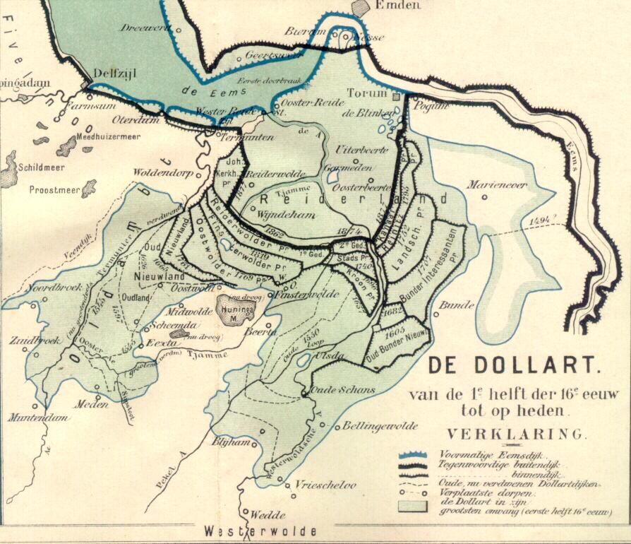
Everybody probably knows about the southwest delta – the delta where in 1953 a big flood hit the Netherlands, and the region where the Delta Works have been constructed. But we have another delta, the Ems delta, in the northeast of the country, covering the province of Groningen. To be more precise, the region can be classified as a Dutch-German delta, because a large part of the estuary lies in Germany, and the river Ems that flows into the estuary comes from there as well. The Dollard is a kind of spatial depression or delta lake in open connection to the Ems, which is characterized by a century long history of settlements, land reclamation, coastal flood disasters and flooding. Over time, lands have been reclaimed and lost again (including settlements) to the sea several times.
(source: http://www.weikopiebes.nl/ and http://en.wikipedia.org/)
De Graanrepubliek deals with developments in agricultural polders bordering the Dollard. Those polders are typical ‘delta polders’ in the sense that the soils are extremely fertile, supporting the most productive farms of the Netherlands at the time. The farmers produced wheat – of similar importance as rice in food production and consumption in the Asian deltas. The period after the 1960s was socio-economically very dynamic: it was a time when discussions arose about the relation between farmer workers, and the large farmer landowners that got rich by producing wheat, the socio-political tensions that this brought, the interest in socialism, mechanisation in agriculture, and the unification of Europe.
All these developments contributed to what I study in my research: the flooding, or de-poldering, of delta polders. The book describes how European agricultural policy in the 1960s and 70s led to a huge overproduction of wheat. Realizing that maintaining what in fact was a highly subsidized agricultural production system, the Dutch Sicco Mansholt (who was actually born in Groningen, the Ems delta), vice minister of for agriculture in Europe, reduced the formerly ‘guaranteed’ price that would be paid to farmers for their wheat.
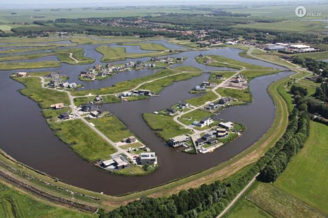
The farmers in the Ems delta felt the consequences. Farming wheat became much less profitable, and new plans that were in favour of continued support for agriculture did not pass through the political system. Instead, environmentalists and spatial planners got enthusiastic about other uses of the delta landscape. Instead of farming, which was said to be unprofitable, bad for the environment because of its use of fertilizers and massive wheat production, those social groups wanted the plan ‘Blauwe Stad’ (Blue City).
(Source: https://klaasantonmulder.wordpress.com)
Plan Blauwe Stad wanted to flood some agricultural polders in the delta and construct villages around a newly formed delta lake. It was envisaged that many, especially rich city dwellers would favour a house in such an area, with new nature and options for recreation, all supported by a large water body covering some of the most fertile delta soils in the Netherlands. This would stimulate a different type of economic activity in the region: no more agriculture, but delta leisure. A long story short – the plan was accepted and in 2005 about 1200ha agricultural land was converted into 400ha of new nature and 800ha of water (lake Oldambt).
Now, several years later, Frank Westerman explains in an added chapter that those expectations did not materialize. Only a very small percentage of the plots has been sold, and the province has let go the original plan. It is now presented as a nature development plan with some supportive economic activities and the task to act as a water storage basin in times of high rainfall or river discharge.
All in all a very fascinating story. A typical delta story: dynamics at the border of land and water, times of land (reclamation), of disasters (1877), and since recently also of intentional flooding. But first, it’s time to prepare for a next delta tour up north, to take a first-hand look!